Wednesday, April 9, 2025


KATHMANDU: Kailali is a district located in the Sudurpaschim Province of Nepal, situated 688 kilometers west of the federal capital, Kathmandu. The district is a mix of both plains (Terai) and hilly terrain. It covers an area of 3,235 square kilometers, with 40.35% of the land being mountainous and 59.75% being flat plains. The elevation of the district ranges from 109 meters to 1,950 meters above sea level, and the administrative headquarters of Kailali is in Dhangadhi.
The district experiences an average annual rainfall of 1,840 mm, and its temperatures vary from a minimum of 5°C to 19°C during the winter months, while in the summer, the temperatures range from 19°C to 46°C. Due to the migration of a large number of people from hilly areas, the population in the district has been growing rapidly.
The name Kailali has various theories surrounding it. In ancient times, Kailali was part of the Kalabanjar Kingdom, and its capital was a village that is now known as Kailali. The name might have originated from this area. This place was also historically referred to as Kalapani, where criminals were sent into exile as punishment. The nearby river, which once flowed under the name Kalapani, is now known as Khutiya Khola.

Total Population of Kailali district. (Source: National Population and Housing Census 2021)
Kailali is home to several significant religious sites, including Shivpuridham, Godawari Dham, Shree Kartikeya (Mohanyal), Shree Singhasan, Behadababa, Lakshminarayan Temple, Nainadevi Temple, and Bandevi Temple, among others. Notably, Godawari Municipality, situated next to the Badi Macheli River, is famous for the Gwasi Samaji Temple, where animal sacrifices are part of religious rituals.
Kailali is made up of 6 rural municipalities, 6 urban municipalities, and 1 sub-metropolitan city, adding up to a total of 13 local levels. They are:
Dhanghadi Sub Metropolitan city
Tikapur Municipality
Ghodaghodi Municipality
Lamkichuha Municipality
Bhajani Municipality
Godawari Municipality
Gauriganga Municipality
Janaki Rural Municipality
Bardagoriya Rural Municipality
Mohanyal Rural Municipality
Joshipur Rural Municipality
Kailari Rural Municipality
Chure Rural Municipality
Dhangadhi Sub-Metropolitan City, located in Kailali District, lies at an altitude of 109 meters above sea level. It is situated 750 kilometers away from the federal capital, Kathmandu, and consists of a total of 19 wards. Covering an area of 261.75 square kilometers, the geographical landscape of Dhangadhi is predominantly flat. To the east, it borders Kailari Rural Municipality, while to the west, it is bounded by the Mohana River. To the north, it borders Godawari Municipality and Gauriganga Municipality, and to the south, it shares an international border with India, along with the Mohana River.
The average maximum temperature in Dhangadhi is 45°C, while the minimum temperature is recorded at 7°C. Due to the diverse ethnic groups and communities residing in the area, a variety of festivals are celebrated. Major festivals include Dashain, Tihar, Maghi, Holi, Gora, Aulke, Maghe Sankranti, Krishna Janmashtami, Bakar Eid, Ulle Eid Fitr, Aitabari, Chhath Festival, Buddha Jayanti, and Christmas.
This area, located in the eastern part of Kailali District, lies 14 kilometers south of the Mahendra Highway and 14 kilometers north of the Indian border, on the western bank of the Karnali River. The region is characterized by dense forests. There is a belief that the settlement pattern of the villages in this area, which are arranged in a circular shape resembling a tikka, led to the name Tikapur. Another belief is that the name Tikapur originated because the clearing of the forest for settlement began on the day of Dashain, the festival associated with the tika (a traditional mark).

Population by sex and 5-year age group in Kailali district. (Source: National Population and Housing Census 2021)
Located in the central part of Kailali District, Ghodaghodi Municipality is bordered by Bardagoriya Rural Municipality to the east, Gauriganga Municipality to the west, Mohanyal Rural Municipality to the north, and Bhajani Municipality to the south. The municipality covers an area of 354.44 square kilometers. It is home to communities with diverse languages, cultures, traditions, and customs. The municipality has the largest number of community forests, and it is also known for its numerous lakes and ponds. Among these, Ghodaghodi Lake, which is listed in the Ramsar Convention as a wetland of international importance, is a notable attraction.
Lamkichuha Municipality is a municipality located in Kailali District, in the Far Western Province of Nepal. It is connected to the East-West Mahendra Highway. The average temperature in this area is 41°C, with the minimum temperature recorded at 10°C. Lamkichuha Municipality is situated 13 kilometers to the east of the Karnali River. To the north, it borders Mohanyal Rural Municipality, to the west, it borders Bardagoriya Rural Municipality, to the east, it is bounded by the Karnali River and Bardiya District, and to the south, it borders Janaki Rural Municipality, while Joshipur Rural Municipality lies to the southwest.
Bhajani Municipality is located in the central southern part of Kailali District, in the Far Western Province of Nepal. To the east, it borders Tikapur Municipality and Joshipur Rural Municipality, to the west, it borders Kailari Rural Municipality, to the north, it shares borders with Ghoda Ghodi Municipality and Joshipur Rural Municipality, and to the south, it is adjacent to the Tikunia and Belraiyan areas of Uttar Pradesh, India.
The municipality is home to the Mohana River, located in wards 3 and 8, where one can spot the endangered aquatic species, the Dolphin, making it a potential tourist destination. However, the region is also prone to severe flooding, erosion, and inundation, which cause significant damage to hundreds of hectares of farmland every year, leading to food shortages and posing a risk to settlements. Bhajani Municipality experiences the highest level of flood-related damage in Kailali District.
Godawari Municipality, located in the central-western part of Kailali District in the Far Western Province of Nepal, is considered a region of religious significance. The area is irrigated by the sacred Godawari River, which holds deep importance for Hindus. Nestled in the foothills of the Chure Mountain Range, the municipality is situated 15 kilometers north of the district headquarters, Dhangadhi, and 25 kilometers north of the Nepal-India border.
The northern part of the municipality is hilly, with several ridges, while the southern part consists of the Terai plains. In terms of climate, the municipality experiences a warm tropical climate in the plains, while the hilly areas enjoy a temperate climate. The area is highly fertile, suitable for all types of agricultural crops, and is also well-suited for fruit production, making it a productive and viable area for farming.
Gauriganga Municipality is located in Kailali District, in the Far Western Province of Nepal. It spans between 28° 38’’ to 28° 51’ 30’’ north latitude and 80° 54’ 30’’ east longitude, at an elevation ranging from 165 meters to 944 meters above sea level, and is situated 622 kilometers from Kathmandu.

Sex ratio, population density, and annual population growth rate in Kailali district. (Source National Population and Housing Census 2021)
To the east, it borders Ghodaghodi Municipality, to the west, Dhangadhi Sub-Metropolitan City and Godawari Municipality, to the north, it is bounded by the Chure Range and Mohanyal Rural Municipality, and to the south, it borders Kailari Rural Municipality.
In terms of climate, the municipality experiences a variety of weather conditions, including tropical, subtropical, temperate, and moderate climates. The maximum temperature is around 37.2°C, while the minimum temperature is 7.1°C. The area receives rainfall from both the monsoon and westerly winds.
Janaki Rural Municipality is located in Kailali District, in the Far Western Province of Nepal. It is situated approximately 10 kilometers south of Lamki Chowk, which is located on the East-West Highway.
The municipality is home to people from various ethnicities and religions. According to the census data, the largest ethnic group is the Tharu, with 29,799 people (59.8%), followed by the Chhetri with 5,378 people (10.8%) and the Brahmin (Hilly) with 4,822 people (9.7%).
The municipality is equipped with educational institutions offering education from the basic to the secondary level.
Bardagoriya Rural Municipality is located 50 kilometers east of Atariya, the capital of the Far Western Province. To the north, it borders Mohanyal Rural Municipality, to the south, it borders Joshipur Rural Municipality, to the west, it borders Ghoda Ghodi Municipality, and to the east, it borders Lamki Chhuh Municipality.
This municipality falls under Kailali District, one of the 22 Terai districts of Nepal. Except for Ward No. 2, all other wards of Bardagoriya Rural Municipality are situated on flat land.
Mohanyal Rural Municipality is located in the hilly region of Kailali District.
The municipality borders Surkhet District to the east, Chure Rural Municipality to the west, Dotile and Surkhet Districts to the north, and Gauriganga Municipality, Ghoda Ghodi Municipality, Lamki Chhuh Municipality, and Bardagoriya Rural Municipality to the south.
The total area of the municipality is 626.95 square kilometers. It is situated at an altitude ranging from 1,100 meters to 1,700 meters above sea level, with the Chure Mountain range extending across this region.
In terms of forest resources, Mohanyal Rural Municipality is considered one of the leading municipalities in Kailali District.
The climate of this municipality varies from tropical to temperate, with the average temperature ranging between 19°C to 37°C.

Marital status in Kailali district. (Source: National Population and Housing Census 2021)
Kailari Rural Municipality is located 27 kilometers east of the district headquarters, Dhangadhi, in Kailali District. The municipality is situated at an elevation of 135 meters above sea level and experiences a tropical to subtropical climate.
To the north, Gauriganga Municipality borders Kailari, to the south, it shares a border with Uttar Pradesh, India, to the west, it borders Dhangadhi Sub-Metropolitan City, and to the east, it borders Ghoda Ghodi Municipality and Bajani Municipality.
The entire terrain of this municipality is flat, with an elevation ranging from a minimum of 155 meters to a maximum of 170 meters above sea level. The total area of the municipality is 233.27 square kilometers.
Within Kailari Rural Municipality, there are small parks and picnic spots, making it a popular recreational destination. Additionally, every year during the month of Magh, a fair is held at the Ban Devi Temple and the Aparampara Temple in Kailari to celebrate Maghi, a local festival.
Joshipur Rural Municipality is located in Kailali District, which is part of the Far Western Province of Nepal. Situated in the southern part of Kailali District, this municipality borders Lamki Chhuh and Tikapur Municipalities and Janaki Rural Municipality to the east. To the west, it borders Ghoda Ghodi Municipality and Bajani Municipality, while to the north, it borders Bardagoriya Rural Municipality, and to the south, it shares a border with Bajani Municipality.
The total area of Joshipur Rural Municipality is 65.57 square kilometers. The terrain ranges in elevation from a minimum of 148 meters to a maximum of 162 meters above sea level. Almost half of the municipality is covered by forest areas and wetlands.
Chure Rural Municipality is a beautiful municipality, filled with natural beauty. To the east, it borders Mohanyal Rural Municipality of Kailali District, to the west, it borders Badikedar Rural Municipality, to the north, it borders Jeraial Rural Municipality, and to the south, it borders Godawari Municipality of Kailali District. The total area of Chure Rural Municipality is 493.18 square kilometers.

The average age of first marriage in Kailali District. (Source: National Population and Housing Census 2021)
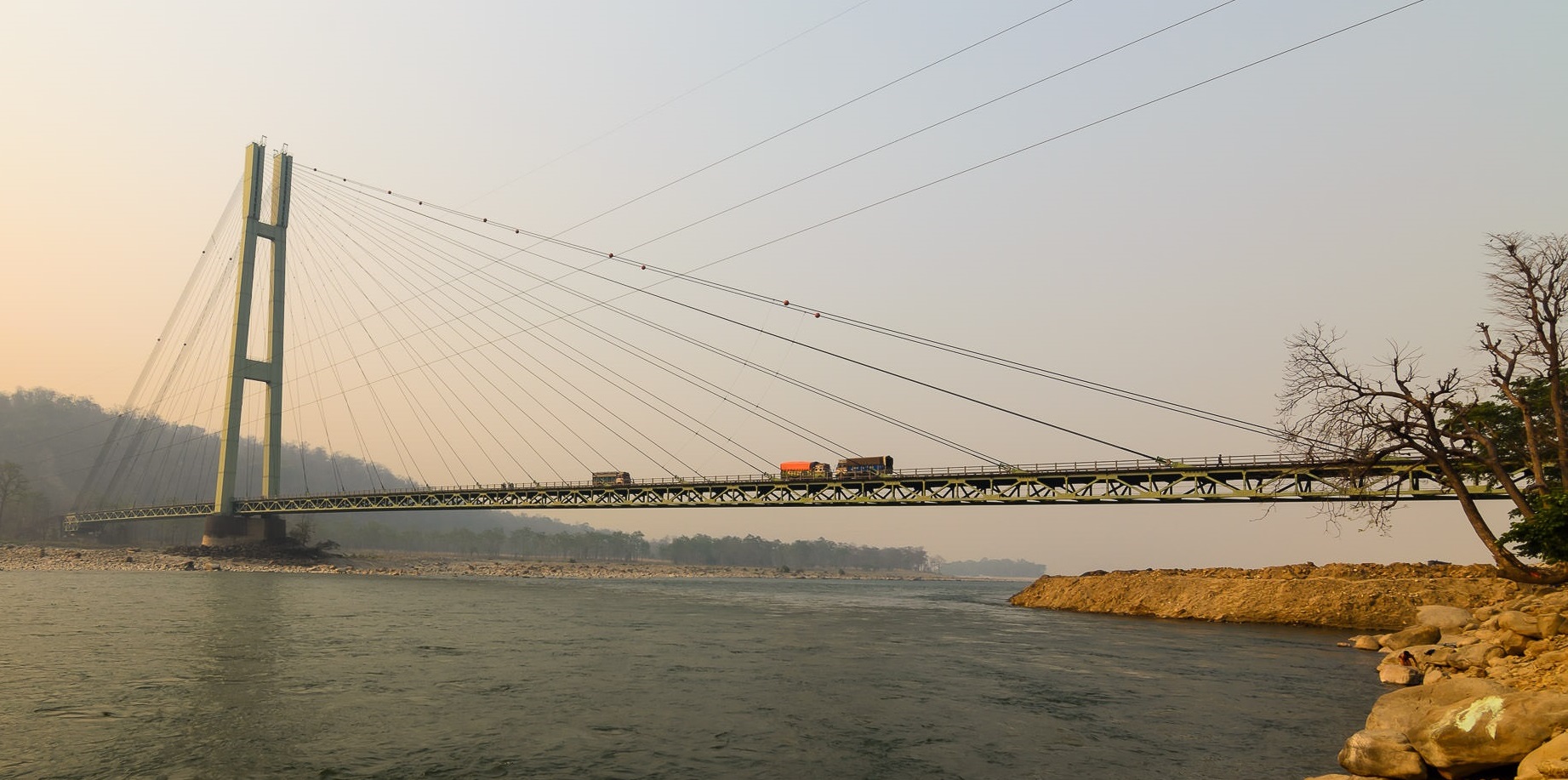
The district also boasts numerous historical and mythological tourist destinations. One of the prominent sites is the Karnali River and the bridge constructed over it, which serves as a vital link between the far western region of Nepal and the rest of the country. The Rajkanda area, located 16 kilometers north of Lamki in Mohanyal Rural Municipality-7, is another popular spot known for its sunrise views. In addition, the construction of a cable car from Karnali Chisapani to Rajkanda is underway to boost tourism in the area.
Tikapur Park is another highlight, covering 5 hectares and modeled after the Swiss city of Luxal. The park is famous for its 80 varieties of roses and numerous plant species, making it a popular spot for picnics. Additionally, the area gained historical significance when King Mahendra ruled Nepal for a month from this location in 2028 BS. Another key religious site is the Prakasheshwar Mahadev Temple in Satti Bazar of Tikapur Municipality, which is known for its rare and large Shivalinga. It is believed that visiting this temple fulfills one’s wishes.
One of the most well-known natural attractions is the Ghoda Ghodi Lake, located in the central part of the district, 60 kilometers east of Dhangadhi and 37 kilometers west of Karnali Chisapani. This lake, which spans 2,563 hectares, is part of the Ramsar List of Wetlands of International Importance. The area is a haven for birdwatchers, with over 245 species of birds and numerous reptiles and plants. The lake is surrounded by 19 smaller lakes, adding to its allure.
Garva Durbar, situated in the Khairala area of Chure Rural Municipality, is the only Rana-era palace in the far western region of Nepal. Although it is in a deteriorated state, it holds immense historical importance. The palace, constructed in 1982 BS, is accessible after a 6-hour walk from Choumal.
For those interested in local culture, Bhada Village in Dhangadhi Sub-Metropolitan City-16 is famous for its Tharu lifestyle and culture. The village offers visitors an opportunity to experience the traditional Tharu way of life and food.
Another important religious site is Godawari, located 7 kilometers north of Attariya. This sacred place, often referred to as the Haridwar of the region, draws many Hindu pilgrims. The temple here is home to the tallest statue of Bajrangbali Hanuman in Nepal, standing at 52 feet.
Lastly, Khanidanda, located in Chure Rural Municipality, is a scenic spot offering a unique experience of both warm and cool temperatures. It provides spectacular views of the surrounding hills, plains, and even the Api Himal.
Kailali is a district that offers a combination of natural beauty, cultural heritage, and religious significance, making it a fascinating destination for both domestic and international tourists.