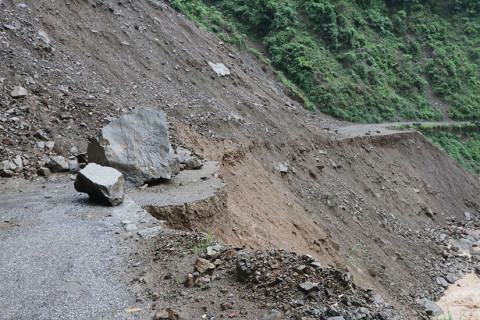
NASA on Thursday launched an online platform with information on how much water evaporates into the atmosphere from plants, soils and other surfaces in the US West, data it says could help water managers, farmers and state officials better manage resources in the parched region.
The platform, OpenET, uses satellite imagery from the Landsat program, a decades-long project of NASA and the US Geological Survey that records human and natural impacts on Earth’s surface.
Specifically, it provides data for 17 Western states — down to the quarter-acre — on how much evapotranspiration has taken place. That’s the process by which moisture in leaves, soil and other surfaces evaporates into the air.
The West has been mired in drought for more than two decades. Scientists say human-caused climate change has intensified conditions. Water levels at key reservoirs on the Colorado River have fallen to historic lows alongside growing demand, prompting the federal government to declare water cuts for some states next year. A blazing summer and years of record-breaking wildfires have also zapped moisture from the ground.
Detailed information on soil moisture could help farmers and water managers better plan during dry conditions and reduce how much water is used for irrigation, NASA scientists said on a Thursday call with reporters.
READ ALSO:


1672397318_80X80.jpg)


1672397318_680.jpg)